
Hikers, fear no more: the Houghton trails can now be explored with the aid of a map. Although it is a longstanding feature of the college’s wild surroundings, the Houghton trail system remained in dire need of an updated map until the fall of 2017. As the semester progressed, Eco Reps and student Elijah Tangenberg ‘20 converged on the same idea: a GIS survey of the trails to provide a satellite-based map available to students and the public. While Eco Reps’ first GIS project involved mapping the domestic and wild trees around campus, they also wanted to create a visual of the seven miles of walking paths on Houghton property. Fortunately for the organization, Tangenberg had recently developed a web app housing a satellite survey of the trails as an extracurricular project for REC 227 in the fall semester.
 Tangenberg took on the project as a combination of service and learning, wanting to refine his skills with GIS (Geographic Information Systems) while simultaneously providing a resource to the campus. “I had worked with GIS before, and I’m probably going to continue working with it,” said Tangenberg. He described the technology as “a very ubiquitous tool that people use for virtually anything that has to do with where data is on a map.” His current project is helping to design ARC-GIS Hub, a data-sharing tool for a non-profit in his home state of California. “I’m interested in water management,” he explained, “and it’s one of the primary water-management tools out there – and understanding GIS is just a major asset no matter what you’re planning on doing with geography, or design, or environmental policy.” Despite this, he noted, “It’s very rare to have a lot of undergrad involvement in GIS, and most of the time it’s in the context of landscape design, or real estate – there’s not a lot of environmental focus.”
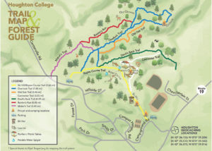
While Tangenberg notes significant improvements in GIS since the days when the trails were originally designed and mapped by a team including Coach Bob Smalley and Doris Nielsen (of Nielsen Center fame), the technology originated in the 1960’s and was used to map the original trails with reasonable accuracy. However, the old map no longer gives a very good picture of what you would find on a hike in the Houghton forest. “Over time, the trail system kind of evolved,” explains Tangenberg, “And over time we actually experienced a period of trail loss.” The T-shaped intersection between the Connector Trail and Devil’s Back used to be a four-way stop, for instance, with the Connector Trail making another loop on the opposite side. This is the version of the trails recorded in Smalley’s original map. “If you go there today,” says Tangenberg, “There’s a good chance you’ll get lost, because that trail simply doesn’t exist anymore.”
Tangenberg hopes the up-to-date map will allow students to hike the trails with confidence and responsibility. “Mabel’s trail, in my mind, is one of the trails that I would want to see more used,” he specifies, “because it’s just not on the beaten path for a lot of people. It’s usually a trail that people get lost on . . . but it’s a beautiful trail.” According to Tangenberg, Mabel’s trail was named for Doris Nielsen, “as a little signature on her role in the project”. Tangenberg also hopes to see the map used in the maintenance and stewardship of the trails and in encouraging student accountability and engagement. “The one thing I would emphasize is that the trail system is there to be used,” affirms Tangenberg, “and with the trail map, it’s now much easier for somebody to navigate it and to interact with it better. And that’s the whole reason why it exists in the first place. You can go out, learn about our area, walk around with friends, stay out overnight, use it as a retreat space and as a space to reconnect with your vocation in God.”